

A hidden region where the blue sea and deep greenery spread out, and the sea and mountains are two sides of the same coin
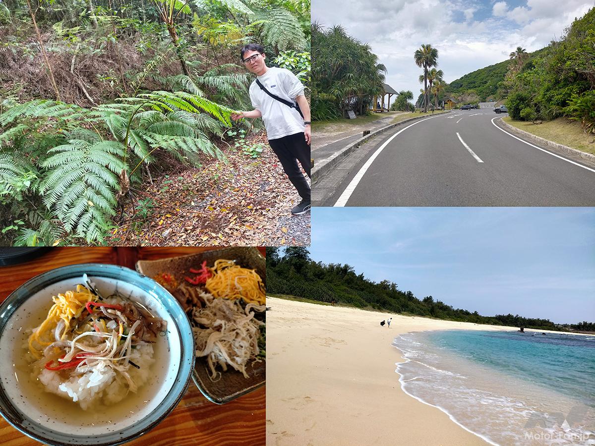
The beach at Ohama Seaside Park faces the Sea of Japan. The waves were relatively calm on the day of the visit.
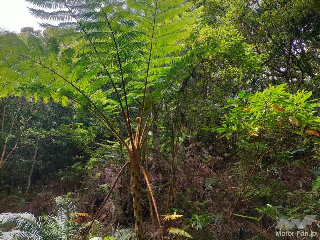
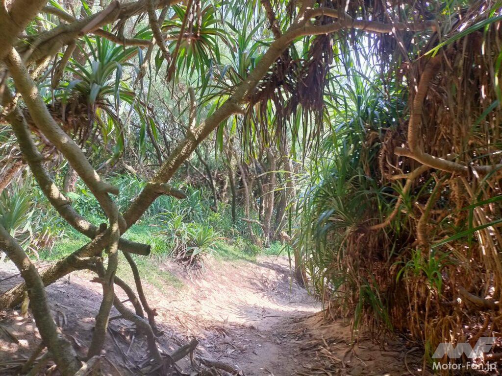
The wilderness of Amami Oshima is lush with giant ferns and other plants that are registered as a World Heritage Site.
Amami Oshima is a remote island in Kagoshima Prefecture, located approximately 380km from Kagoshima City. It is the second largest of Japan’s remote islands after Sado Island in Niigata Prefecture, and is characterized by being mostly mountainous with little flat land. The island is made up of Amami City, Setouchi Town, Tatsugo Town, Yamato Village, and Uken Village.
The total area of Amami Oshima is approximately 712 km2 (square kilometers). People who are unfamiliar with Amami Oshima tend to imagine it as a small island when they look at it on a map, but Tokyo’s 23 wards are approximately 620 km2, Lake Biwa is approximately 670 km2, and Awaji Island in the Seto Inland Sea in Hyogo Prefecture is approximately 592 km2. In other words, Amami Oshima is quite a large island.
The distance around the island is about 460 km. If you travel by motorcycle (excluding 50cc mopeds), it takes about two hours to travel from the north to the south one way. Even a simple round trip takes four to five hours. There are only regular roads, no expressways.
For example, if you were to cycle around the island without making any detours, it would take just under 10 hours if you were to travel at a speed of 40km/h. So if you want to see all the famous tourist spots, you’ll want to stay for at least two nights and three days.
Amami Oshima is a place where the blue sea and the deep green of mangroves and other plants spread out, and in short, it is a place where the sea and mountains are two sides of the same coin. On July 26, 2021, the natural beauty of Amami Oshima, as well as Tokunoshima, northern Okinawa Island, and Iriomote Island, was registered as a World Natural Heritage Site.
Amami Oshima is where Saigo Takamori of the Satsuma Domain was exiled to the island at the end of the Edo period and ordered to live in hiding in the Tatsugo area, where he spent over three years. The island is also famous for being featured in the NHK historical drama “Segodon.” The wooden house where he lived at the time still exists and is open to the public as a prefectural cultural property, “Saigo Nanshu Exile Site,” along with a stone monument with calligraphy by Katsu Kaishu and other related items (an admission fee is required to visit).
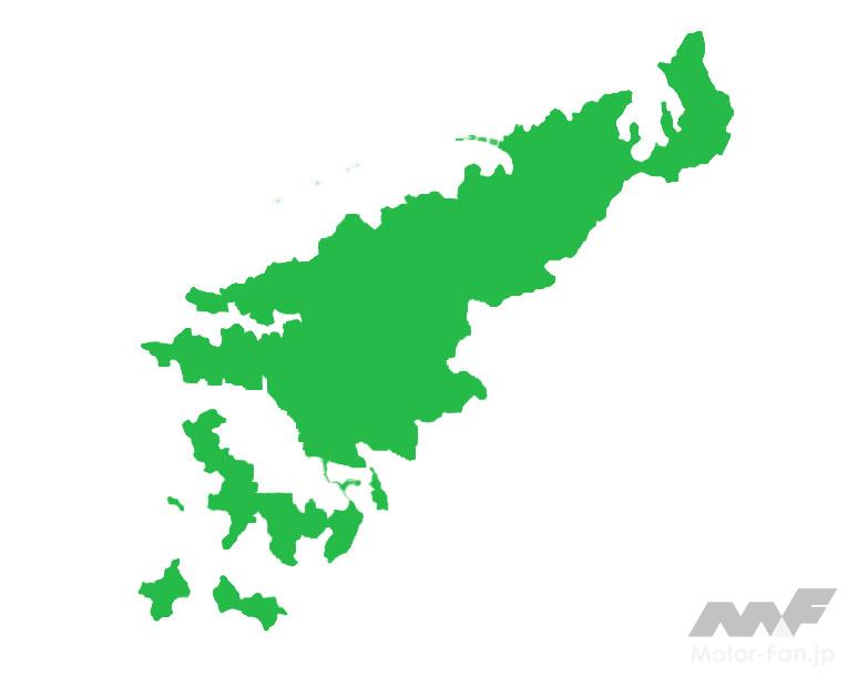
The topography of Amami Oshima.
ADVERTISEMENT
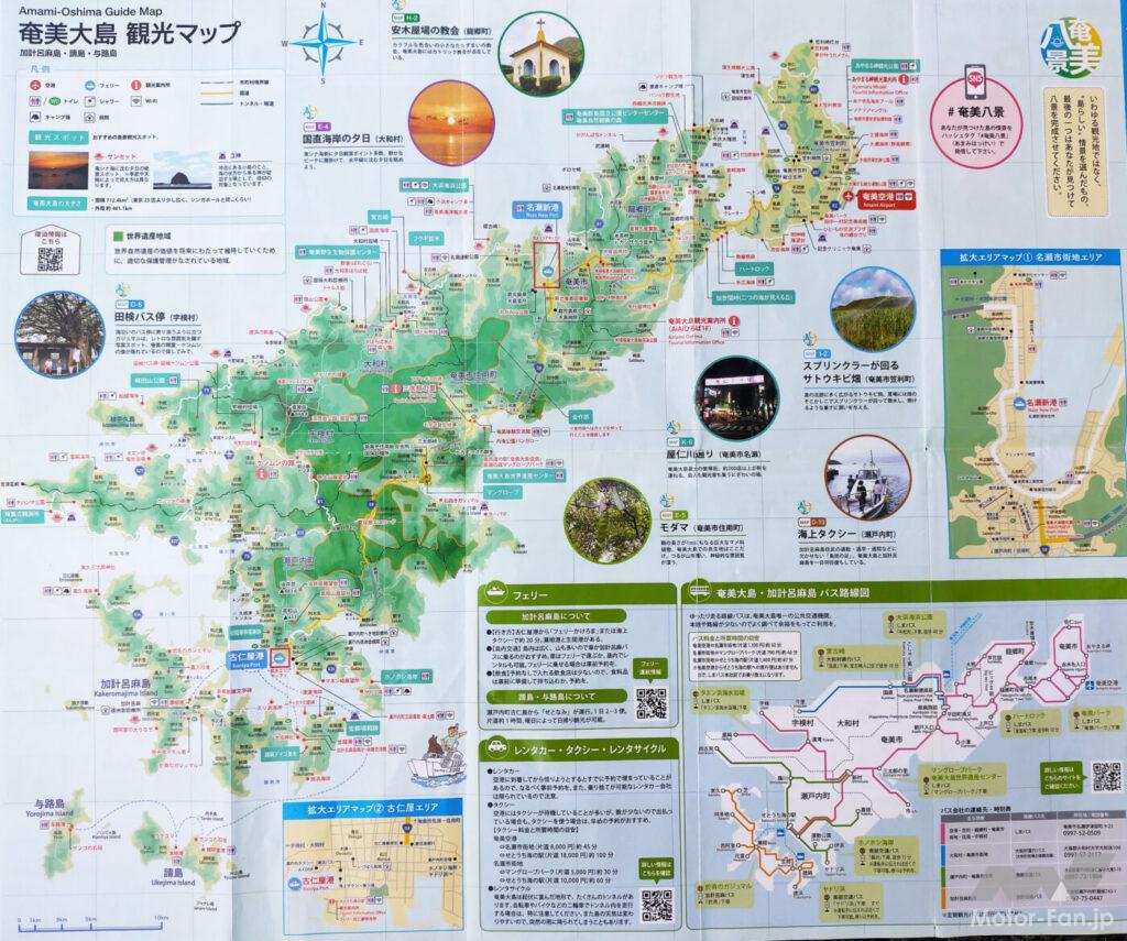
From a tourist guide map distributed free of charge at Amami Oshima Airport and other locations.
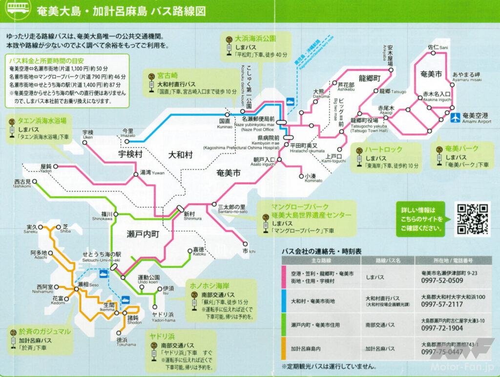
From a tourist guide map distributed free of charge at Amami Oshima Airport and other locations.
Experience the differences between each beach! This is also the best part of touring Amami Oshima
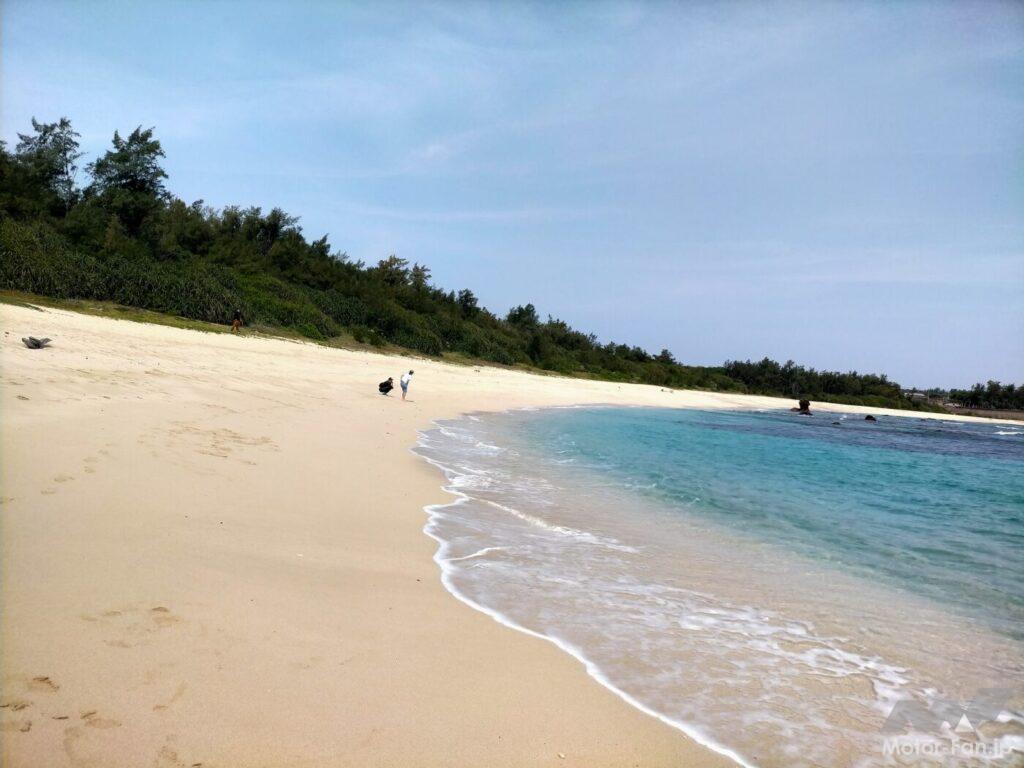
Domori Beach faces the Pacific Ocean. The waves were rather large on the day of the visit.
From a tourism perspective, Amami Oshima can be roughly divided into three parts: the north, central, and south. The north is dotted with beautiful beaches, the central area is the city and main port, and the south is mainly a ria coast (though there are beaches, though not as many as in the north). And the island has an image of having mountains in the middle of it all.
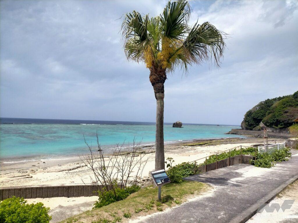
The island faces the Pacific Ocean and the Sea of Japan, and is divided into intricate bays in places, giving the beaches and coastal areas very different looks. In the case of beaches, the waters directly facing the Pacific Ocean and the Sea of Japan have quite a lot of waves, so strong that the outgoing tide can sweep away both your feet.
On the other hand, the indented bay has calm waves and is very quiet, with no sound of waves. If you want to spend a relaxing time, we recommend staying at a hotel along the bay.
However, what they all have in common is the spectacular emerald green color that is unique to Amami Oshima. I visited for three days in April, and the first day was sunny with occasional clouds, the second day was cloudy with occasional sunshine, and the third day was rainy and then cloudy. However, the color of the sea was emerald green everywhere on all three days, and it never became cloudy even on rainy days.
What’s interesting about Amami Oshima’s beaches is that the size of the sand particles, the size of the stones, and the appearance of the rock surface vary depending on the location. One of the joys of Amami Oshima is visiting each beach and experiencing the differences.
The overwhelming three-dimensional effect is as if a bright green cauliflower is thrust before your eyes.
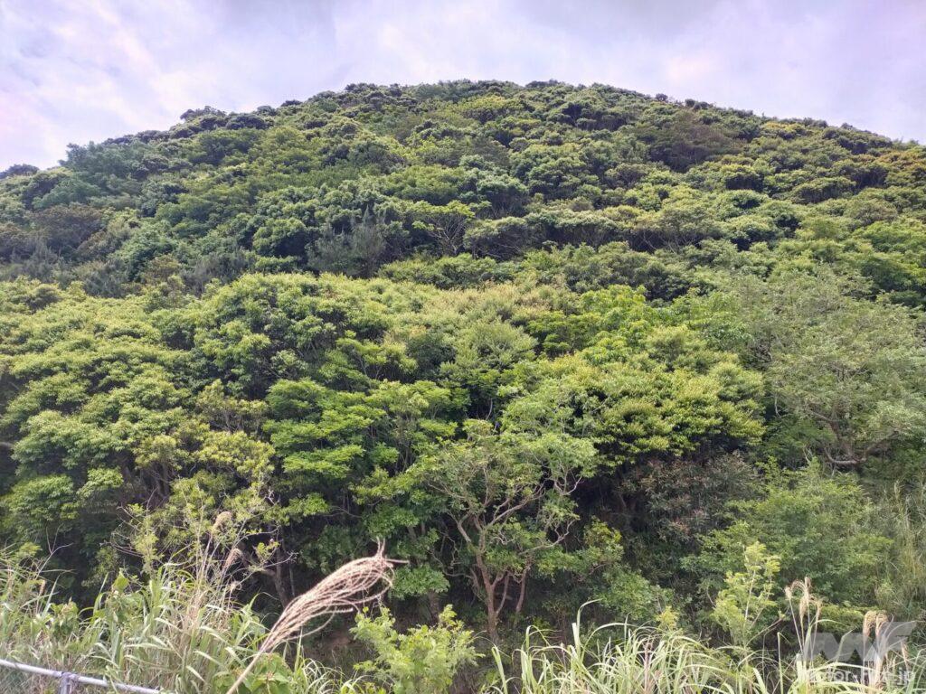
A mountain near Kinsakubaru, a World Heritage Site.
The greenery of the mountains and landscapes of Amami Oshima are simply profound. It is like a row of countless giant, bright green cauliflowers, thrust before your very eyes, creating an overwhelming sense of three-dimensionality that catches your eye. The stunning deep green color is clearly different from the mountains on the mainland. When you see this impressive sight with your own eyes, you will instantly understand why it was designated a World Heritage Site.
On both sides of the road cut through the mangroves, huge ferns the size of an adult man’s upper body (or even larger) grew, creating a tropical atmosphere. I also came across a flower that I had never seen before, one that can only be seen on Amami Oshima.
For long tours such as going around the island, a 125cc class or larger bike will be smooth.
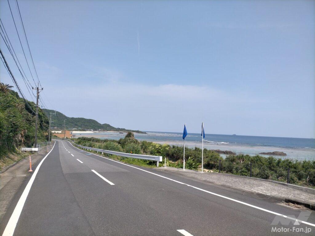
On Prefectural Route 82, a coastal road with a great view that leads to Kasarizaki Lighthouse, the northernmost point of Amami Oshima.
The roads are basically one lane in each direction except in urban areas and uphill lanes. They are no different from well-maintained roads in the mainland, and the pavement is in good condition, making them very easy to drive on.
However, except in urban areas, traffic is generally light, and local cars seem to be in a good mood and drive quite fast. I was on a mountain pass road with many curves when a light minivan driven by a local resident passed me by in an instant as I approached the climbing lane (I was afraid to follow them after that, so I sent them off with a wish to be safe).
Amami Oshima has towering mountains with its back to the sea, and many roads with continuous slopes. So, for example, if you’re going on a long tour around the island, a 50cc moped might be too tough for a guy like me who’s over 50 and has lost his energy and stamina.
People who want to travel short distances on the island or ride long distances at a leisurely pace. Also, if you are confident in your energy and stamina, a 50cc would be fine, but if you want to ride smoothly and without stress, you’ll want a 125cc moped (class 2 or higher). Is this the same as riding on the mainland?
What is the best season for touring Amami Oshima?
Check out the weather for the past three years!
ADVERTISEMENT
Mangroves leading to the beach where Amami Oshima’s tourist attraction, Heart Rock, is located.
The subtropical Amami Oshima is an area with changeable weather throughout the year and a lot of rain. The rainy season begins around mid-May and ends between late June and early July. The probability of rain is extremely high during this time, so it may be best to avoid traveling there. Also, the humidity is higher during the rainy season and summer than on the mainland, so be careful of heatstroke (and be careful of poisonous habu snakes in the mountainous areas).
Amami Oshima is a rainy place, but if you’re a student or have a lot of freedom when it comes to choosing your travel dates, you should check the weather forecast for the next three years on the online “Amami Oshima Past Weather” website. If you narrow your search to dates that have a clear weather forecast for the past three years, you’ll statistically increase your chances of having good weather.
Amami Oshima’s average annual/monthly temperatures
ADVERTISEMENT
| month | Amami Oshima | Tokyo |
| Average annual temperature | 21.8℃ | 15.8℃ |
| January | 15.0℃ | 5.4℃ |
| February | 15.3℃ | 6.1℃ |
| March | 17.1℃ | 9.4℃ |
| April | 19.8℃ | 14.3℃ |
| May | 22.8℃ | 18.8℃ |
| June | 26.2℃ | 21.9℃ |
| July | 28.8℃ | 25.7℃ |
| August | 28.5℃ | 26.9℃ |
| september | 27.0℃ | 23.3℃ |
| October | 23.9℃ | 18.0℃ |
| november | 20.4℃ | 12.5℃ |
| december | 16.7℃ | 7.7℃ |
From the Naze Meteorological Observatory website : https://www.jma-net.go.jp/naze/
Climate characteristics of Amami Oshima by month
| Annual | The climate of the Amami region is generally referred to as a subtropical oceanic climate, and as it is surrounded by a warm sea, it is warm and humid throughout the year, with an average annual temperature exceeding 20°C. Precipitation is also high, with the average annual rainfall in Naze, Amami City exceeding 2,800 mm, and the average annual sunshine hours are low compared to the rest of the country, at 1,332.1 hours. |
| January February | In Amami, there are few days when the temperature drops below 10°C even in the mornings and evenings, and during this time, cold air from the continent causes convective clouds to flow in one after another over the surface of the East China Sea, resulting in intermittent rain and cloudy days with little sunshine. This is also the time when the Hikanzakura cherry blossoms, which are rare on the mainland, bloom. |
| March April | Around this time, the temperature becomes suitable for the activity of the Amami Habu snake. Just like on the mainland, yellow sand can be observed in Amami. |
| May June | The rainy season in the Amami region begins about a month earlier than in the mainland, and usually begins around May 12th and ends around June 29th. At the height of the rainy season in June, warm and humid air flows in from the edge of the Pacific high pressure system, causing heavy rain. |
| July August | After the rainy season ends, there are many sunny days, and unless a typhoon comes, there is no significant rain. However, caution is needed as the ground heats up due to the effects of sunlight, which causes updrafts to form, and the cumulonimbus clouds created by these updrafts can bring localized heavy rain. Maximum temperatures exceed 30°C every day, making for midsummer days, and tropical nights. |
| September October | Typhoons can approach from July and August until around this time, so you need to pay close attention to their movements. The heat of September is still intense and there are still many days that reach midsummer, but as October arrives, there will be days when the temperature drops below 20°C in the mornings and evenings. |
| November December | In November, northerly winds become dominant, and the number of summer days with maximum temperatures above 25°C finally decreases. In December, the temperature drops further and the weather becomes relatively dry. |
From the Naze Meteorological Observatory website : https://www.jma-net.go.jp/naze/